Diet/Exercise/Health/Wellness Support Thread

<p>Hey, idad, thanks for the link! I just ordered it and agree this seems more sensible for me since I am given to be outdoors a lot and despite my mosquito guy’s best efforts, living between a river and woods means there’s no such thing as mosquito-free zones around here. Supposed to be a bad year for ticks too, and I saw this first hand when we uncovered the old lodge to discard the blankets!</p>

<p>MomWC, sending you the “healing butt mojo.” :wink: I know that tune firsthand and have been known sit on those 3-pronged wood-ball massagers to attempt to release.</p>

<p>Thanks. I went from doing pretty well yesterday morning to barely being able to walk. It’s like something is pinched and nothing I am doing in the way of stretching, pigeon poses and releases is helping. It’s not comfortable, to say the least. I may not be able to get the mile in, although with the Hokas on, the pain is less. I may try some swimming today if I can locate the goggles etc.</p>

<p>Here’s the shoe I bought yesterday. Admit while it feels like a very good fit I was hugely drawn in by the color! Guess my $60 tent sale price was pretty decent ! Will be a good traveling shoe - hopefully will be good for running, trail walks, etc.<br>
<a href=“http://www.amazon.com/New-Balance-W890-Limited-Edition/dp/B005XKCUZU/ref=sr_1_6?s=shoes&ie=UTF8&qid=1400424511&sr=1-6&keywords=new+balance+890v2+women”>http://www.amazon.com/New-Balance-W890-Limited-Edition/dp/B005XKCUZU/ref=sr_1_6?s=shoes&ie=UTF8&qid=1400424511&sr=1-6&keywords=new+balance+890v2+women&lt;/a&gt;&lt;/p&gt;

<p>Well, it’s a racing shoe for 5 minute milers. :slight_smile: We expect some good things from you, abasket! It sure is pretty!<br>
Did one 12 minute mile. This may be the end of the streak unless whatever is pinching in there eases up.</p>

<p>In other news, my son’s girlfriend won the Red Bank (NJ) Tri this morning and he won the AquaVelo (swim/bike) which I didn’t even know he was doing. He posted, "The real question isn’t ‘Did you win the race?’ but ‘Did you beat your girlfriend’s bike split?’ ". </p>

<p>^LOL. :slight_smile: Congrats to the kiddos.</p>

<p>MOfWC, I’m joining kmcmom in sending you some good butt mojo. I know how frustrating this can be, especially when something like a streak or an upcoming race is on the line! Cyberhugs. </p>

<p>plantmom:</p>

<p>Thanks for the NYTimes article link. David Ludwig is a major bigshot obesity researcher endocrinologist. Now, I’ve got to wade thru his new JAMA article linked in the NYTimes article.</p>

<p>author:</p>

<p>Yeah, YouTubes are great for “pre-testing” a hiking trail, trying to get a feel for what conditions are like. I did just get a little video camera (the Garmin version), but all the stuff I linked was taken with a cheapo $99 Nikon Coolpix point 'n shoot. Mostly still pictures.</p>

<p>The best waterfall hike in NH will be in today’s batch.</p>

<p>Well, I made my pool debut. It’s been several years since I’m done “real” swimming. Managed 1000 yards, and I’m sure I’ll be sore. Did 200 straight to open up, and then took some breaks and mixed in some kicking and other strokes. It felt good to stretch out. I can walk a little better than earlier today, but something is still really off.</p>

<p>Thanks for the butt mojo! </p>

<p>Apparently they swam through total muck and just a couple feet of water in the Red Bank tri. They exited the water covered with mud on their faces etc. Sounds lovely. I think it was low tide.</p>

<p>Nice swim!!! Some cross training overall might be a really good thing !!
Yes, I saw that about the 5 min miles- Ill Just double up with a hearty 10 mi mile . :)</p>

<p>“Apparently they swam through total muck and just a couple feet of water in the Red Bank tri. They exited the water covered with mud on their faces etc. Sounds lovely. I think it was low tide.”</p>

<p>Lovely, indeed. That’s the major deterrent for me to even try a tri. Too many Canada geese and ducks around here… Speaking of geese, I saw multiple families of them - with fluffy grey goslings during my run today. 6 miles, 7:45 pace. Mid-sixties and partially sunny. Everything decided to bloom at once! </p>

<p>These hikes are all in the Crawford Notch area. Take RT-3 east from Franconia to RT-302. It’s about 30 minutes. In the area is the legendary [Mt</a>. Washington Hotel<a href=“site%20of%20the%20Bretton%20Woods%20Conference%20at%20the%20end%20of%20WWII%20and%20probably%20a%20nice%20place%20for%20a%20fancy%20lunch!”>/url</a> and the new [url=&lt;a href=“http://media.outsideonline.com/images/highland-center_fe.jpg]Appalachian”&gt;http://media.outsideonline.com/images/highland-center_fe.jpg]Appalachian</a> Mountain Club Highland Center lodge](<a href=“http://upload.wikimedia.org/wikipedia/commons/1/18/Mount_Washington_Hotel_2003.JPG]Mt”>http://upload.wikimedia.org/wikipedia/commons/1/18/Mount_Washington_Hotel_2003.JPG) that was built on the site of another historic old inn. It’s also where the [Mt</a> Washington Cog Railway](<a href=“http://www.thecog.com/]Mt”>http://www.thecog.com/) departs for the steep climb.</p>

<p>Arethusa Falls</p>

<p>This is the best waterfall in NH. I would make this a very high priority when planning your hikes. It’s awesome. There are two options for the hike. One is straight 3 mile out and back hike (about 975 feet of elevation) on a relatively easy trail – just the usual NH rocks and roots. This one took me 2 hours 15 minutes last fall, including sitting on rock admiring the falls and eating a snack. There’s a short detour to Bemis Brook on this option that winds along the brook and then climbs a steep hillside on roots to get back to the trail. If you want to do the Bemis Brook option, probably going is better than coming. The second option is a 5.5 mile loop (1800 feet of elevation) up to a view from Frankenstein Cliffs and circling back down to the falls. The loop is great, but you can also combine just the Arethusa Falls bit with one of the other short hikes in the area (Ripley Falls or Mt. Willard).</p>

<p>Trailhead is on a road that turns to the right off RT 302 about six miles south of the Highland Center. There’s a lower parking lot (with restroom), but if you go up the road a few hundred yards, there’s an upper lot by the train tracks that is much closer to the trails. For Arethusa Falls, you cross the tracks and head to the left. For Frankenstein Cliffs you head to the right, either along the tracks or along the parallel trail into the woods below the tracks:</p>

<p>[Map[/url</a>]
[url=&lt;a href=“- YouTube”&gt;- YouTube]My</a> YouTube](<a href=“http://■■■■■■■.com/koeenx3]Map[/url”>http://■■■■■■■.com/koeenx3)
Parking GPS: N44 08.873 W71 22.165</p>

<p>Ripley Falls
This another short waterfall hike just up the road from Arethusa Falls. It’s a short 1.2 mile round trip with about 400 feet of elevation gain to an attractive waterfall/cascade. Took me about an hour including waterfall watching. I did this as a pair with Arethusa Falls last fall during foliage season. You can actually hike between them, but it’s a long boring trail with not much other and slogging up and down through the woods. Better to drive the couple of miles between the trailheads and do them as a pair of short waterfall hikes, IMO.</p>

<p>Trailhead is on Wiley Station Road that turns to the right off RT 302 about four miles south of the Highland Center. </p>

<p>[Map[/url</a>]
My YouTube: see end of Arethusa Falls video
Parking GPS: N44 10.031 W71 23.171</p>

<p>Mt. Willard</p>

<p>Another awesome short hike in Crawford Notch. This one is widely considered to be the best view for the effort involved in the White Mountains. In many ways, it’s the best view, period. Another high priority hike! It’s a 3.3 mile out and back round trip with 975 feet of elevation gain. Easy terrain, mostly on an old dirt logging road/horse path. Steady uphill, but pretty smooth hiking by White Mountain standards. The view! Wow. At the top, you are standing on a 1000 foot rock cliff looking straight down the length of Crawford Notch. Super nice little hike. Took me 2 hours 45 minutes including hanging out on the summit for quite a while.</p>

<p>Trailhead is literally just across the railroad tracks behind the Crawford Notch station next to the Highland Center. The old train station is now tourist info (and restrooms!) Walk across the track and the trail crosses a field of wildflowers into the woods. In a few hundred yards, the Willard Trail splits to the left. Avalon Trail straight ahead. Avalon is also a nice hike, but more strenuous (4 mile round trip 1600 feet of elevation, pretty rough footing in places).</p>

<p>Doing Arethusa Falls and Mt. Willard would make a pretty nice day of easy/moderate hiking. Great view on one hike. Great waterfall on the other. I usually do one or the other on my final day of camping in the area. Break down camp. Short hike in the early afternoon, then drive home. Usually by the third day in a row of hiking, my legs are pretty much toast anyway.</p>

<p>[url=&lt;a href=“http://■■■■■■■.com/lvl9jhc]Map[/url”&gt;http://■■■■■■■.com/lvl9jhc]Map[/url</a>]
[url=&lt;a href=“- YouTube”&gt;- YouTube]My</a> YouTube](<a href=“http://■■■■■■■.com/k25jcpf]Map[/url”>http://■■■■■■■.com/k25jcpf)
Parking GPS: N44 13.076 W71 24.664</p>

<hr>

<p>Next installment: Big hikes from Crawford Notch in the Presidentials around Mt. Washington.</p>

<p>Six hours in the garden–put in 85 plants. I’m counting it as a workout. Only took a break for lunch and water. My back will feel this tomorrow–lots of up and down–we have a woodland garden so no nice raised beds!
Like your shoes abasket–great color.
Idad: thank you for the great hiking info. My youngest will be in NH for a week this summer–teaching drama at the Y camp where she was a camper and counselor. I am going up to bring her home and we will definitely do one of the hikes.
Feel better–MOWC.</p>

<p>3.1 mile run, new record for my garmin lol! No speed demon (and no not a sub 10 minutes miles :slight_smile: ). 9 holes of golf, walking. Out to dinner, glass of wine with a grilled salmon salad. Good day. I’m pooped!</p>

<p>*Three weeks and three countries later…</p>

<p>Nine hikes and a hundred prayers later…</p>

<p>Countless laughs and invaluable experiences gained later…*</p>

<p>and I’m back. :)</p>

<p>Never have I ever felt so close to death in my entire life. To those who do hikes, I, a native-born Floridian whose definition of a hill in a 10 ft elevation, applaud you. </p>

<p>South America has taught me what a mountain is! :)) All I can do is laugh because I would have never thought I would’ve done this in my entire life! Hike a mountain? What? Let alone trek across three countries while being disconnected from the modern world? What? =)) </p>

<p>This trip was insane and I don’t regret it.</p>

<p>Yay Niquii. I’ve been wondering how your trekking has been going. Glad to hear the trip was an adventure.</p>

<p>I don’t do scary fear-of-heights or OMG I could fall stuff. I just decided that I don’t enjoy being scared, I don’t need to be scared, don’t have anything to prove, so I leave that to the youngsters!</p>

<p>It was an adventure alright. The trip changed a lot last minute, but when money has been paid for and booking have been placed, you just have to go with the flow. It was more than I could’ve imagined. The people were so friendly. The views were so beautiful. The air was so pure and thin! </p>

<p>The goal wasn’t to make everyone scared. It was an adventure trip. You can’t get up into the countryside of Peru via teleport. (I wish!) You just have to suck it up and look forward to the next sight. Can’t live your life in fear, you know?</p>

<p>It’s sort of funny how you say you can’t do scary fear-of-heights things, but these people live in it. We got to meet this one local who walked us up to his potato farm. He hikes two or three hours up the mountain just to check up on his farm. Like, man. Wow. A twenty minute walk across campus in August sun would’ve gotten groans from me! </p>

<p>This trip gave me a lot of perspective and a new hunger to travel. Plans to go to Central America are already underway.</p>

<p>author:</p>

<p>OK, here come the big hikes in Crawford Notch. As you drive past the Mt. Washington Hotel and the Highland Center, to the west of the road is a ridgeline of peaks – Webster, Jackson (4052 ft), Pierce (4310 ft), Eisenhower(4780 ft), Monroe (5384 ft), and Mt. Washington (6288 ft). Because of the history of the area as a tourist location, the oldest mountain trails in the country climb up to these peaks from various points. The ridgeline trail connecting them (also part of the Appalachian Trail) is mostly above treeline, subject to unbelievably horrible weather (full west wind exposure, but staggeringly pretty on a nice day.</p>

<p>I’ve climbed three of them so far. Jackson (and Webster) is a miserable hike. The trail is rough, rocky, and muddy. It’s the shortest of the three hikes I’ve done, but the most exhausting because the footing is so bad and the top section is quite steep (like hanging onto trees beside the trail steep). Pierce is a really nice hike up the oldest footpath in America (the Crawford Path). Awesome hike. But the one to do is Eisenhower. Usual caveats about the weather. Don’t go if it’s stormy. The summits will be socked in the clouds, the wind will be howling, and it’s just plain dangerous. But, if you get a nice day, this is an awesome hike. Take jackets, a hat, and some gloves. I hiked it in mid August and had to put a jacket on above tree line. Right now, all of these trails still have rotten ice and snow above 3500 feet, but that should be disappearing quickly over the next couple of weeks.</p>

<p>Mt. Eisenhower</p>

<p>This is a straight up and back 6.7 mile round trip hike up what is considered to be the epitome of White Mountain trail building – the Edmands Path, known for its gentle grades. That’s a relative term. It gains 2900 feet in just over three miles with most of that coming once it turns uphill after an easy first mile. Still, there’s not much steep scrambling. The footing is good. And, it’s an enjoyable hike. Once you hit the top of the ridge (the Crawford Path) you make a right turn for a steep final leg up the Eisenhower Loop to a totally exposed summit with 360 degree views. AMC book time is 4 hours 45 minutes. Took me 7 hours 10 minutes. It’s a good solid day of hiking.</p>

<p>To get to the trailhead, drive past the Mt. Washington Hotel and just as you crest the hill approaching the Highland Center, take a left on Mt. Clinton Road (Hiker Trailhead signage). The Edmand Path parking lot is on the right 2.3 miles down Mt Clinton RD after the turn. This is a White Mountain National Forest lot (as opposed to a state park) and probably requires the usual fee (I think $3) deposited in an envelope in a self-serve kiosk.</p>

<p>[Map[/url</a>]
[url=&lt;a href=“- YouTube”&gt;- YouTube]My</a> YouTube](<a href=“http://■■■■■■■.com/ok9u384]Map[/url”>http://■■■■■■■.com/ok9u384)
Parking GPS: N44 14.942 W71 23.472</p>

<hr>

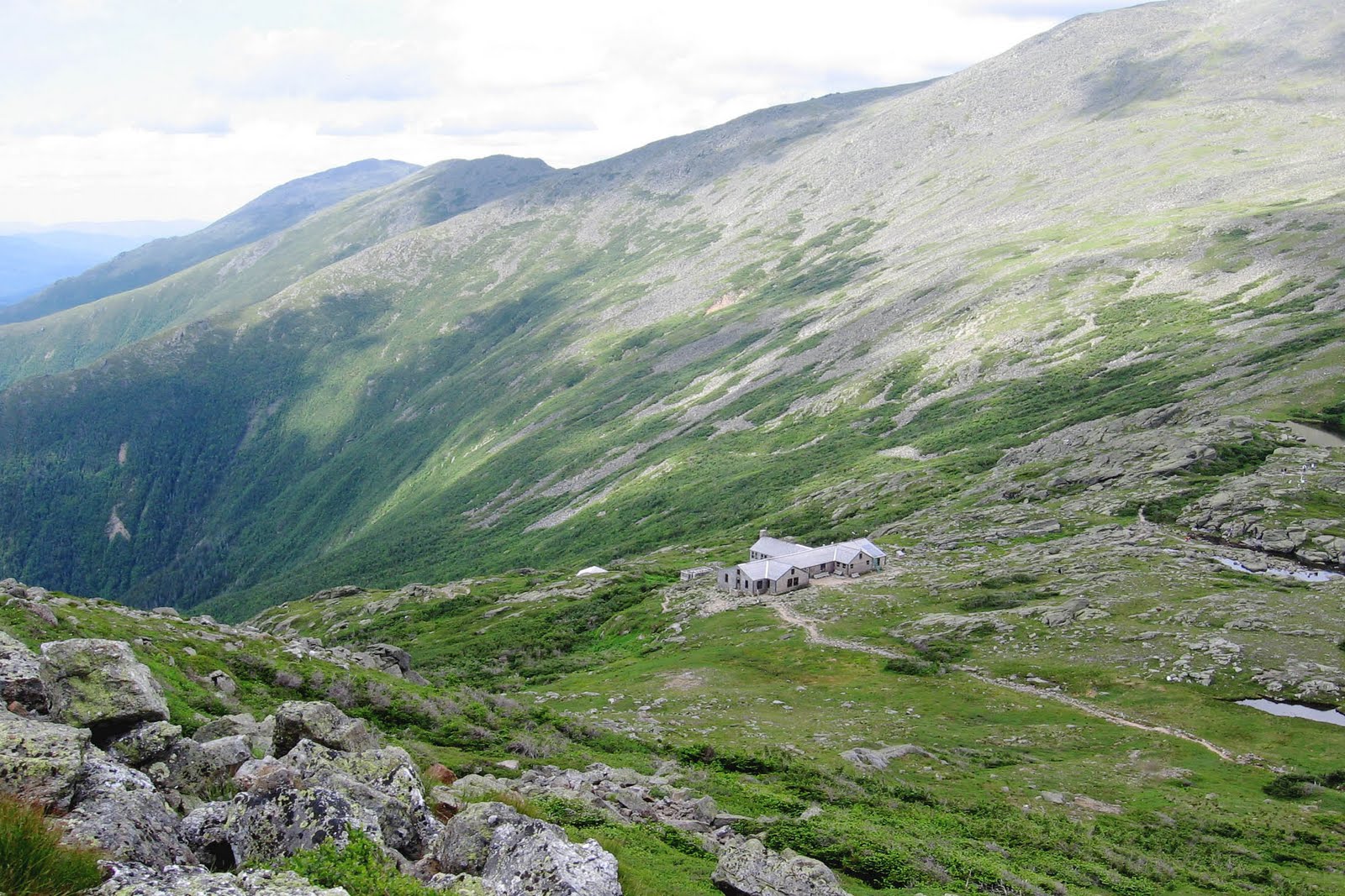
<p>OK, if you get a wild hair to climb Mt. Washington, this is the side to climb from. Don’t be tempted by the better known Tuckerman’s Ravine route from the east (Pinkham Notch near the auto road entrance). Parts of Tuckerman’s trail are actually closed right now due to avalanche danger. And much of it has warnings about the danger of falling ice. Even after the ice and snow is gone, it has some very steep climbing. The “easier” route is from the west, basically paralleling the route of the Cog Railway. The next trail north from the Eisenhower route is the Ammonoosuc Ravine Trail. It leaves from a lot near the Cog Railway station and climbs 3.1 miles and 2600 feet to the [AMC</a> Lake of the Clouds Hut](<a href=“http://4.bp.blogspot.com/-RMYQiQq4pzY/TWWzeT5Pt_I/AAAAAAAABI4/5Hc_266wd6M/s1600/hut.jpg]AMC”>http://4.bp.blogspot.com/-RMYQiQq4pzY/TWWzeT5Pt_I/AAAAAAAABI4/5Hc_266wd6M/s1600/hut.jpg) in the col between Monroe and Washington. 1500 feet of that is in the last mile starting from Gem Pool waterfall with a lot of rock that is often wet and slippery. From there, it continues another 1.5 miles to the summit of Mt. Washington for a total climb of 4.7 miles and 3890 feet. Unless it’s dry, people generally do a loop and descend the Jewel Trail, which is slightly longer but doesn’t have the steep section. The loop is 9.7 miles. You are above tree line for an extended period, so you have to watch the weather pretty closely. I can’t give you a video or a GPS track because I’ve not done this hike, but it’s pretty easy to find info.</p>

<p>He didn’t say he CAN’T do scary, fear of heights things. He said he DOESN’T do them. It’s a choice. He does plenty of challenging hikes. Like, man. Wow! </p>

<p>I’ll definitely add those mountains to my To Do List as options, interesteddad. The elevations were the height at which we were at. I enjoyed the hike most definitely. (I enjoy it more as I look back than when I was actually hiking.) It’s something I’ve never done before so I just want to try more and more!</p>

<p>The most difficult part for me was the altitude. I never quite got used to it. </p>

<p>One really cool things was how thin the air was. When we got to the peak of one of our hikes, some of us were frantically waving our hands through the air. You could barely feel the air. Come to think about it we must’ve looked crazy! :)) </p>

<p>Niquii:</p>

<p>Those were for Author, who is planning a trip to the White Mountains! Crossfire of two different coversations. :)</p>

<p>I’m jealous of your hiking in South America. It must have been spectacular. I have to look at hiking like a workout. That is, I expect it to be hot, sweaty, and hard. It’s almost like throwing a switch when I start out to get into that mind set. It’s unbelievably good exercise. I wish I had done it my entire life instead of taking a 40 year break…</p>